The main task of the Avalanche Warning Service of the ICGC (UPA) during the winter season is the avalanche forecasting. Daily the UPA carries out the avalanche bulletin according to the European avalanche danger scale of 5 degrees (from 1 low up to 5 very high). In case of esteemed danger such as level 4 high or 5 very high the UPA carry out special warnings (APA) addressed to Civil Protection exclusively as established in the special civil protection plan ALLAUCAT.
The two main objectives in the frame of the project are: 1) improvement of the forecasting issues in critical situations which involves risk and the attainment of APA and 2) supply a tool to help in the process of decision making.
- The analysis and the assessment of major avalanches occurred in the past and the prediction of new scenarios will allow to refine the APA fulfilment and risky scenarios. Thus, the participation in the project will allow to update the major avalanche scenarios in the Pyrenees of Catalonia in the frame of climate change. A special focus on vulnerable sites will be done in order to increase the safety and to improve the forecasting for critical situations and the issue of APA.
On the other hand, there is a tool for the process of avalanche forecasting that allows the assessment of the snowpack stability in a systematic risk based workflow. The Platform of information of avalanche Hazard called PIPA is a tool that enables the daily forecasting by using the conceptual model to asses snowpack stability. The platform is made up of different levels that are defined as follows. Levels 10 and 11 make up the tool.
- First level: access into the application using a user and password for each forecaster, selection of the snow-climate zone to be assessed, date of realization and date of validity of the forecasting.
- Second level: definition of the scope and the scale of forecasting.
- Third level: input of the main snow and weather data.
- Fourth level: definition and ranking of the snowpack layers that have the main role in the stability.
- Fifth level: Definition of the avalanche situation (problems) associated with the layers defined in the previous stage.
- Sixth level: Definition of avalanche triggering probability according to the spatial distribution (elevations, orientations and spots in danger) and the sensitivity to triggers for each one of the problems defined in the previous stage.
- Seventh level: danger diagram showing the avalanche triggering probability in relation to the expected avalanche size.
- Eighth level: stage where each predictor writes additional comments to monitor the avalanche situation.
- Ninth level: forecasted danger degree for the next 24 hours and its trend for the 48 and 72 hours. It includes the level of confidence level according to the number of data, level of experience, level of reliability of weather forecasting, among others.
- Tenth level: outline of the situation with the visualization of the most relevant features of the previous levels. This summary is used as a communication tool for the different stakeholders: civil protection, observers and forecasters prior to the issue of APA or BPA.
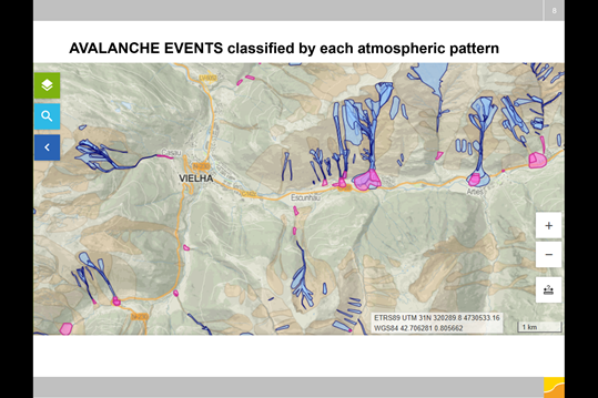
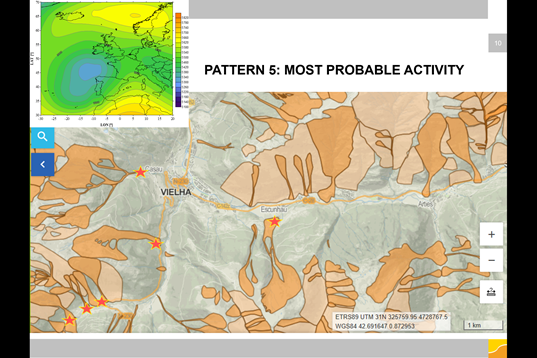
- Eleventh level: definition of the critical situation that would rely on the outline and the most similar major avalanche pattern and the forecasted avalanche activity with a map.
Eina visual de gestió de situacions d’emergència en cas d’alt risc d’allaus
Una de les tasques fonamentals que la Unitat de Predicció d’Allaus de l’ICGC (UPA) té assignada durant la temporada hivernal és la realització de la predicció de perill d’allaus. Diàriament la UPA realitza el butlletí de perill d’allaus en base a l’escala europea de perill d’allaus (EEPA) que té cinc graus, de l’1 feble fins al 5 molt fort. En cas de situacions d’elevada perillositat, grau de perill fort 4 i molt fort 5, la UPA elabora avisos de perill d’allaus (APA) adreçats únicament a Protecció Civil tal i com es contempla en el pla de Protecció Civil ALLAUCAT (Pla Especial d’Emergències per Allaus a Catalunya).
L’objectiu principal en el marc del projecte és doble: 1) millorar les prediccions en el cas de situacions crítiques i que impliquin risc i generació d’APA i 2) dotar d’una eina que ajudi a la presa de decisions:
- La valoració i anàlisi de situacions de grans allaus, que han ocorregut en el passat i la previsió de nous escenaris permetrà afinar l’elaboració d’avisos i d’escenaris de risc. Per aquest motiu la participació en el projecte servirà per actualitzar els escenaris de grans allaus al Pirineu de Catalunya en el marc del Canvi Climàtic, tot i fent un èmfasi especial a les zones vulnerables amb l’objectiu d’incrementar la seguretat i la previsió de situacions crítiques i l’emissió d’APA.
D’altra banda, per poder fer la predicció d’allaus, es disposa d’una eina que permet fer la valoració de l’estabilitat del mantell nival a partir d’un flux de treball estructurat i sistemàtic tot seguint una sèrie de passos. La Plataforma per a la Informació del Perill d’allaus (PIPA) és una eina que permet fer aquesta valoració diària seguint un model conceptual per a la valoració del perill. Consta de diferents nivells que es defineixen tal i com segueix a sota i dels quals els darrers nivells (10 i 11) serien l’eina.
- Primer nivell: entrada a l’aplicació amb usuari i password per cada predictor, selecció de la zona nivoclimàtica a valorar, data de realització i de validesa de la predicció que es faci.
- Segon nivell: definició de l’àmbit de predicció i l’escala a la que es prediu.
- Tercer nivell: entrada del resum de dades diàries nivometeorològiques.
- Quart nivell: definició i categorització de les capes del mantell nival que tenen el rol principal en l’estabilitat del mantell.
- Cinquè nivell: definició de la situació d’allaus associada a les capes definides en l’estadi previ.
- Sisè nivell: definició de la probabilitat de desencadenament d’allaus a partir de la localització (cotes, orientacions i distribució del perill) i la sensibilitat per a cadascun dels problemes definits en l’estadi previ.
- Setè nivell: diagrama de perill on es representa la probabilitat de desencadenament en relació amb la mida d’allau prevista.
- Vuitè nivell: nivell intern per a cada predictor on anotar comentaris addicionals de seguiment de la situació d’allaus.
- Novè nivell: avaluació del grau de perill a 24 h. vista i la seva tendència a 48 i 72 h. Inclou el nivell de confiança de la predicció en base al nombre de dades, nivell d’experiència, nivell de fiabilitat de la meteorologia prevista, entre d’altres.
- Desè nivell: quadre resum de la situació amb la visualització dels trets més rellevants dels nivells previs. Aquest resum serveix d’eina de comunicació per els diferents agents: protecció civil, observadors i predictors previ a l’emissió d’APA o BPA.
- Onzè nivell: definició de la situació crítica que inclouria un quadre resum amb el pattern de grans allaus més similar i l’activitat d’allaus prevista amb un mapa
Els nivells de PIPA d’1 a 9 estan ja definits i formen part de l’operativa de la UPA. En el marc del RECIPE es treballa en la definició del nivell 10 i 11 i millores en el nivell 3 i 9. Durant el transcurs del projecte, s’aniran definint les tasques de millora i la definició del nivells nous a desenvolupar.